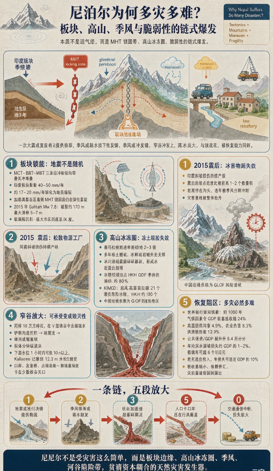
尼泊尔为何多灾多难?——板块、高山与季风的“完美风暴”
Why Nepal Suffers So Many Disasters? — The "Perfect Storm" of Tectonics, Mountains, and Monsoons
引言|Introduction
2026年8月,中尼边境吉隆口岸一带突发特大山洪泥石流,造成中方人员失联、尼方重大伤亡,中尼贸易大通道被迫中断。这并非孤例——2015年8.1级大地震、2021年冰川湖溃决、2025年辛杜帕尔乔克县连环滑坡……尼泊尔似乎总在灾难的阴影下。这个国土面积仅14.7万平方公里、比安徽省略大的山国,为何如此“多灾多难”?
In August 2026, a massive debris flow struck the Gyirong Port area on the China-Nepal border, causing casualties on both sides and forcing the closure of a key trade corridor. This was no isolated incident — the 2015 M8.1 earthquake, the 2021 glacial lake outburst, the 2025 Sindhupalchok landslides… Nepal seems perpetually shadowed by disaster. Why does this mountainous country — smaller than China's Anhui Province — suffer so relentlessly?
答案不在“运气差”,而在地质、地形、气候与人文四重因素的刚性叠加。
The answer lies not in bad luck, but in the rigid superposition of four factors: geology, topography, climate, and human presence.
一、地质本底:坐在板块火药桶上|Geology: Sitting on a Tectonic Powder Keg
尼泊尔位于印度板块与欧亚板块碰撞带的喜马拉雅弧中段。印度板块以约每年40毫米的速度向北俯冲,地壳长期积累应力,属于地中海—喜马拉雅地震带的核心区段。
Nepal sits on the central Himalayan arc of the India-Eurasia plate collision zone. The Indian plate pushes northward at roughly 40 mm/year, accumulating crustal stress in the heart of the Alpine-Himalayan seismic belt.
境内发育多条巨型逆冲断裂——主中央逆冲断裂(MCT)、主边界逆冲断裂(MBT)等,岩层挤压变形、破碎强烈。2015年8.1级大地震不仅当场造成近9000人遇难,更把无数山体"震松震裂",此后的滑坡、泥石流物源,很大一部分来自那次地震遗留的松散碎石。
Multiple giant thrust faults traverse the country — the Main Central Thrust (MCT), Main Boundary Thrust (MBT) — creating intensely fractured and deformed rock. The 2015 M8.1 earthquake killed nearly 9,000 people and, crucially, loosened countless mountain slopes. Much of the debris feeding today's landslides and debris flows originated from that single shock.
结果:地震频发 + 浅表地层松散破碎 = 天生适合崩塌、滑坡、泥石流发生。
Result: Frequent earthquakes + loose, fractured shallow crust = a landscape primed for collapses, landslides, and debris flows.
二、地形:百公里内从8000米跌到百米|Topography: From 8,000 m to 100 m in 100 km
尼泊尔国土狭长,南北宽仅约200公里,却囊括了地球表面最极端的垂直落差:
Nepal is a narrow strip of land, barely 200 km wide north-south, yet it contains one of Earth's most extreme vertical gradients:
- 北部:喜马拉雅山脉,8座8000米以上雪峰,包括世界最高峰珠穆朗玛(萨加玛塔);
- 中部:丘陵与河谷,海拔1000–4000米;
- 南部:特莱平原,海拔仅70–300米。
- North: Himalayan peaks, including 8 summits above 8,000 m, among them Mount Everest (Sagarmatha).
- Central: Hills and valleys, 1,000–4,000 m.
- South: Terai Plain, a mere 70–300 m above sea level.
南北百余公里,高差超过8000米。 这种地形让水流汇流极快、搬运力极强;也让村庄、公路、电站、徒步客栈不得不挤在有限的河谷阶地、冲积扇和沟口——而这些位置,恰好是泥石流和山洪的天然通道。
In barely 100 km, elevation drops over 8,000 m. This gradient makes water converge and accelerate violently, giving flows enormous transport power. It also forces villages, roads, power stations, and trekking lodges onto narrow river terraces, alluvial fans, and gully mouths — exactly the paths of debris flows and flash floods.
全国80%以上国土是山地,宜居土地极少且人口密集。灾害一触发,就是"直接砸在人头上"。
Over 80% of Nepal's territory is mountainous. Habitable land is scarce and densely populated. When disaster strikes, it hits people directly.
三、气候触发:季风暴雨 + 冰川失稳|Climate Triggers: Monsoon Rain + Glacial Instability
季风暴雨|Monsoon Rain
每年6–9月,西南季风为尼泊尔带来全年70%–90%的降水。短时强降雨迅速浸透本就松动的岩土,是滑坡泥石流最普遍的触发剂。
Every year from June to September, the southwest monsoon dumps 70%–90% of Nepal's annual precipitation. Short, intense downpours saturate already-loosened soil and rock — the most common trigger for landslides and debris flows.
冰川失稳与冰湖溃决|Glacial Instability and GLOFs
更隐蔽的威胁来自高山冰冻圈。全球变暖使尼泊尔冰川以每年约0.3–0.4平方公里的速度退缩,冰碛坝(由松散碎石堆成)稳定性变差。高位冰岩崩和冰湖溃决(GLOF)正从"偶发事件"变成"新常态"。
A more insidious threat comes from the high-mountain cryosphere. Global warming is shrinking Nepali glaciers by ~0.3–0.4 km² annually. Moraine dams — piles of loose rock — become unstable. High-altitude ice-rock collapses and Glacial Lake Outburst Floods (GLOFs) are shifting from "rare events" to a "new normal."
2025–2026年吉隆口岸、拉苏瓦一带的突发大灾,并非纯暴雨型,而是"高位冰崩 → 铲刮沟道碎屑 → 堵河成堰塞体 → 瞬时溃决"的链式灾害。这类灾害预警时间常以分钟计。
The sudden disasters around Gyirong Port and Rasuwa in 2025–2026 were not simple rain-driven events, but chain reactions: high-altitude ice collapse → scouring of gully debris → river blockage forming a dam → instantaneous breach. Warning time for such events is measured in minutes.
四、人为叠加:在危险带上继续加压|Human Factors: Adding Pressure on Dangerous Ground
- 陡坡开荒与森林砍伐:削弱植被固土能力,为滑坡提供"助推";
- 沿河无序建设:公路、桥梁、民居、旅游设施推进到行洪廊道,主动把自己送进灾害路径;
- 防灾短板:预警系统覆盖不足,山区交通通信易断,救援直升机受峡谷乱流限制。小概率上游事件容易放大成大规模伤亡。
- Steep-slope farming and deforestation: Weaken vegetation's soil-binding capacity, giving landslides a boost.
- Unplanned riverside construction: Roads, bridges, homes, and tourist facilities encroach into flood corridors, placing people directly in harm's way.
- Disaster preparedness gaps: Inadequate early warning coverage, fragile mountain communications, and helicopters limited by canyon turbulence. Low-probability upstream events easily amplify into mass casualties.
世界银行将尼泊尔列为全球气候脆弱度前列国家,预估若不干预,到2100年灾害年均损失可占GDP近10%。
The World Bank ranks Nepal among the world's most climate-vulnerable countries. Without intervention, annual disaster losses could reach nearly 10% of GDP by 2100.

五、灾害链:为什么"多灾"还"多难"|The Disaster Chain: Why So Many, Why So Hard
尼泊尔的灾难极少是单点事件,而是链式爆发:
- 地震或冰川失稳提供松散物源;
- 季风暴雨或融水触发滑动;
- 窄谷地形将水流与碎屑加速放大为高速泥石流/山洪;
- 人口聚居在河谷行洪带,直接承受冲击;
- 交通通信中断,救援进不去,损失进一步扩大。
Nepal's disasters are rarely single events; they explode in chains:
- Earthquake or glacial collapse supplies loose material.
- Monsoon rain or meltwater triggers movement.
- Narrow gorges accelerate flows into high-speed debris floods.
- Populations cluster on valley flood paths, taking the full impact.
- Transport and communications collapse, blocking rescue and amplifying losses.
四段甚至五段叠加,就形成了今天这种"多灾多难"的刚性格局。
Four or five stages stacked together forge the rigid pattern of relentless disaster.
尼泊尔不是"运气差",而是板块、高山、季风、冰川、人居位置五件事在同一个狭长国土上全部走到极端。任何一项单独搬走,灾害烈度都会大幅下降;五项同框,便是一场旷日持久的"完美风暴"。
Nepal is not "unlucky." It is a place where tectonics, high mountains, monsoons, glaciers, and human settlement have all been pushed to extremes within one narrow strip of land. Remove any single factor and disaster intensity would drop sharply; with all five present, a protracted "perfect storm" is inevitable.
理解这一点,不是为了感叹命运,而是为了更精准地预警、更科学地规划、更有力地援建——让这片雪山之国,在风暴中多一分韧性。
Understanding this is not about lamenting fate, but about enabling more precise early warning, more scientific planning, and more effective aid — so that this land of snow mountains can build greater resilience against the storm.
参考资料|References: 中国外交部、中国地震局、中国科学院、World Bank、ICIMOD等公开报告。|Open reports from Chinese MFA, CEA, CAS, World Bank, ICIMOD, etc.
此文由 怡心湖 编辑,若您觉得有益,欢迎分享转发!:首页 > 常识论 » 尼泊尔为何多灾多难?——板块、高山与季风的“完美风暴” Why Nepal Suffers So Many Disasters?
 大地之怒:泥石流的科普全景 当雨水
 当"硅岛"震颤:熊本地震与世界半导体
 亚洲水塔的黄昏:冰川拐点、气候危机